

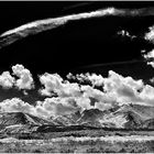
Cloudy Arran Hills
6. April 2013
An diesem Tag wurden die Wolken zu einem bildbestimmenden Element,
aber auch die wuchtige Bergkulisse hat mich beeindruckt.
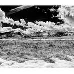
Hills of North Arran (s/w)
Manuel Gloger
Donnie Munro - Catch the Wind: http://www.youtube.com/watch?v=tH20e3gPk_g
Geology of Arran
The rocks of north Arran, are divided geologically from the rest of the island by part of the Highland Boundary Fault - a great crack in the earth's crust which separates Highland Scotland from the Lowlands of the Midland Valley. In Arran, the fault cannot easily be seen at the surface, but it curves round the granite from the coast north of Lochranza to emerge again at the coast at Dougarie.
Igneous rocks, which include granites and lavas, occupy almost half of the area of Arran. These rocks were formed 50-60 million years ago (Tertiary period), when Arran was probably joined to the mainland. At that time, the area was dominated by a large volcano which later collapsed to create a surface depression, or caldera, nearly 5km in diameter. The remnants of this caldera are between the String Road and the Ross Road, although little can be seen at the surface.
In the north, the hills of Arran are carved from the remains of a large mass of molten magma which pushed its way up into the earth's crust. When this molten granite forced its way upwards, it lifted the overlying rocks by around 3000m. As those rocks eroded away, the underlying granite was exposed, which also then began to be eroded, creating the features which are visible today.
Source: http://www.castlekirk.co.uk/geology.html
Comments
10


Information
| Section | Travel: Ayrshire |
| Folders | Schottland |
| Views | 6,664 |
| Published | |
| Language |

|
| License |
Exif
| Camera | NIKON D7000 |
| Lens | AF-S DX VR Zoom-Nikkor 18-105mm f/3.5-5.6G ED |
| Aperture | 8 |
| Exposure time | 1/1000 |
| Focus length | 18.0 mm |
| ISO | 100 |
Embed photo
Include in a comment, a description or a message to show this image.
Link copied...
Click on the link and use the key combination "Ctrl C" [Win] or "Cmd C" [Mac] to copy the link.
Share in Messenger
Insert the following link into the comment field of the desired conversation in Messenger using 'Paste' to send this image in the message.
Link copied...
Click on the link and use the key combination "Ctrl C" [Win] or "Cmd C" [Mac] to copy the link.
Sue Thompson 11/05/2018 11:15
An excellent panoramic scene:))
Mershee 28/07/2014 21:56
Schönes Panorama. Die Konraste sind mir aber ein wenig zu krass.LG Mershee
Ralf Büscher 21/07/2014 19:07
Das macht LuftRalf
Claudio Micheli 20/07/2014 18:53
Bellissima realizzazione.Ciao
† Dieter Uhlig. 20/07/2014 16:19
ansehnlichHGB Digitalfoto 20/07/2014 15:43
Die s/w-Kontraste sind ausgezeichnet mutig herausgearbeitet. Passend dazu Donnie und als alter Runrig-Fan kommt man dabei ins Träumen.Klasse Arbeit von dir.
Gruß
HGB
Olli Edler 20/07/2014 14:29
Moin,WOW ! ! !
hier muß man nicht drum rum reden, schweigen und genießen !
Gruß O.E
Joachim Irelandeddie 20/07/2014 14:08
Eine wundervolle Bergkulisse und schon ein fast bedrohlich wirkender Wolkenhimmel! Die Kontraste sind der Hammer! Ein gute s/w-Bearbeitung und ein sehr gutes Panorama!lg eddie
Stefan Jo Fuchs 20/07/2014 14:01
Im Moment bin ich bei deinen Bearbeitungen oft hin und her gerissen, weil du viel mit großen Kontrasten arbeitest. Hier geht das Konzept aber vollkommen auf, der dunkle Himmel setzt dabei einen heftigen Kontrapunkt zur herrlichen Landschaft!lg stefan
Winfried Mossa 20/07/2014 13:39
Wir waren nur sehr kurz auf dieser schöne Insel.Eine beeindruckende Kulisse, tolle Bearbeitung!
LG Winfried