
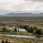
Þingvellir - Parliament Meadows
The location of the Icelandic parliament from 930 to 1789 AD. Now a national park, it is also the site of numerous rifts caused by the separation of the North American and European tectonic plates at the mid-Atlantic ridge, above which Iceland sits. The river Öxará flows through the rift valley into Þingvallavatn, the largest natural lake of Iceland. Þingvellir sits on the north shore of the lake, which is just out of the picture on the right.
My viewpoint was from the largest of the rifts, the Almannagjá.
Panorama stitched from 2 handheld landscape orientation singles shot at 45 mm focal length (equivalent to 72 mm full sensor). Manual exposure at f 11, 1/200 sec, ISO 200.
Comments
1


Information
| Section | Travel: Iceland |
| Folders | Landscapes |
| Views | 3,209 |
| Published | |
| Language |

|
| License |
Embed photo
Include in a comment, a description or a message to show this image.
Link copied...
Click on the link and use the key combination "Ctrl C" [Win] or "Cmd C" [Mac] to copy the link.
R X T 30/06/2010 6:13
Schönes Panorama!Gefällt mir gut.
Gruß RXT