
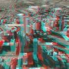
Downtown Denver Aerial - Courtesy of SkylineSoft
This anaglyph was made using SkylineSoft's program TerraExplorer. This program allows you to fly over 3D-mapped USA cities and their vicinity.
By stopping the "plane" at two different vantage points, a 3D stereo pair can be made. The stereo pair is then made into an anaglyph.
Comments
2


Information
| Section | Special: Techniques |
| Views | 2,966 |
| Published | |
| Language |

|
| License |
Embed photo
Include in a comment, a description or a message to show this image.
Link copied...
Click on the link and use the key combination "Ctrl C" [Win] or "Cmd C" [Mac] to copy the link.
Tobias Nackerlbatzl 05/02/2005 18:24
This is an interesting way of producing an anaglyph! Though I have problems getting a concrete picture, that might be due to my TFT monitor. *sigh* Nevertheless, I like it!Cheers,
Tobi.
Roberto Calonge 05/02/2005 12:24
I Like it! It really caught my attention. Congratz.Best Regards. Roberto